 en
en 
 fr
fr es
es de
de
INSTANT - How it works
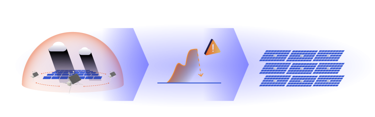
3D mapping of cloud cover and its impact on energy production
3D mapping of cloud cover
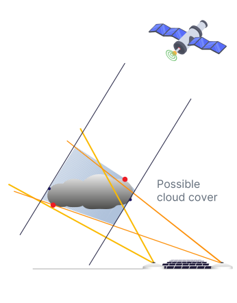
Networked cameras are more precise than a single state-of-the-art camera
A single camera doesn't allow us to model cloud trajectory or thickness with sufficient accuracy
Cloud detection-based forecasting is based on 4 analytical stages performed in real time. The clouds are precisely identified in the images from each hemispherical camera. Locating clouds in space requires several cameras and is based on stereoscopy. By analyzing the position of clouds in space, the shadow can be projected onto the ground and then propagated to obtain highly accurate forecasts over short horizons.
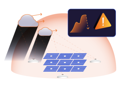
Estimating the impact of the shadow
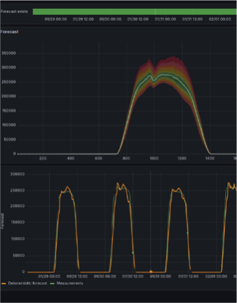
INSTANT estimates the per-minute impact of cloud shadows on PV production
INSTANT models the clouds in 3D in real time, then simulates the shading on the power plant to deduce the time and intensity of the drop in photovoltaic energy production.
Our innovative algorithm, using a geometric approach, statistical learning, and artificial intelligence, is capable of determining cloud speed, altitude, and shape. INSTANT processes hemispheric sky observation images in real time and simulates their impact as early as 1 minute, updating every minute.
Easy integration in your tools
INSTANT integrates with your energy management and trading platforms
Forecasts can be integrated directly and easily into energy management systems and trading platforms.
INSTANT can be integrated directly into your energy management system (EMS). For industry or power plants with storage, an alert system can send an automatic command or issue an alarm to anticipate the start-up of alternative sources or storage discharge.
SEAMLESS & ADAPTATIVE
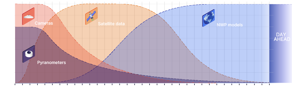
INSTANT's algorithm optimally weights data sources depending on the forecasting horizon to maximize accuracy.
INSTANT’s algorithm dynamically adjusts the weighting of on-site cameras and sensors, satellite imagery, and NWP models to maximize forecasting accuracy.
For short-term horizons (1–30 min), real-time on-site data is prioritized; for longer horizons, satellite and NWP data gain importance. This adaptive approach ensures seamless application across multiple sites and regions bound by different grid regimes, regardless of forecast frequency requirements.
As forecasting frequency requirements evolve (e.g., shifting from 30 to 15 to 5 minutes), INSTANT automatically adjusts the algorithm, eliminating the need for switching between different forecasting solutions. This preserves historical data, enhances model learning, and ensures consistently accurate forecasts as market demands evolve.
Ad hoc configuration
INSTANT ADAPTS TO YOUR NEEDS
Ad hoc configuration that adapts to your needs to prepare the operating plan and readjust your announcements according to your network constraints.
Forecasts with a very high confidence index
INSTANT allows you to prepare your operating plan with energy production scenarios, and to fine-tune your solar energy production announcements to the grid operator in line with current regulations.
Configuration adapted to the photovoltaic plant
Calibsun defines a layout and carries out a climate study upstream of the project to guarantee the best level of performance for your photovoltaic power plant and its geographical location.
Real-time detection of power loss
Qualification of duration and intensity of shading to readjust forecasts or activate alternative energy sources.
FAQ
Learn more about INSTANT
What is cloud detection used for?
Why does cloud detection require observation cameras?
How does cloud detection improve the use of solar energy production?